
GIS and Remote Sensing: Transforming Wildlife Crime Prevention and Conservation
- Mar 7, 2025
- 3 min read
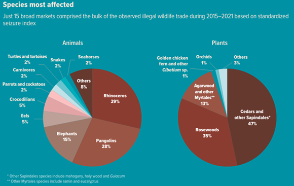
Most of us wish to see all the endangered species, not just survive but thrive so that we may get to see them in their natural habitats someday. But that very wish is threatened by the crimes that are happening in the world of wildlife. Around 400 species that includes both plants and animals are at the risk of being illegally traded. With an estimate
of USD 20 billion per year, Illegal wildlife trade, also considered as 4th largest illicit transnational crime, has become a major challenge in conservation efforts. There are various organisations tasked with responsibility to put an end to organised crimes related to wildlife forming an international consortium on combating wildlife crime. These organisations have carried out operations such as Project predator, Project wisdom, Operation thunderstorm, Operation thunderbird, Operation Worthy II, and Operation paws.
The Kunming-Montreal Global Biodiversity Framework, adopted in December 2022 after four years of consultation and negotiation, charts an ambitious course toward a world in harmony with nature by 2050. Aligned with the Sustainable Development Goals (SDGs), it includes Target 5, which calls for ensuring the sustainable and safe use, harvesting, and trade of wild species.
Various advanced technologies are utilized by the enforcement agencies. GIS and remote sensing is one such tool that plays an essential role in ensuring success of halting the illegal trade in today’s world. Many species can be tracked using integration of AI and satellite imagery allowing enforces and agencies as well as rangers tasked with protecting species to monitor the movement across large landscapes in real-time. This allows teams to reach the location in time when any species are being targeted by poachers and hunters. With the help of GIS and RS analysis, health of forest habitats can be monitored regularly to identify vulnerable patches and to prepare restoration plans for such areas to enhance the health allowing species to survive.
Fragmentation of forest habitats contributes to the increase in vulnerability of many species to poachers as their movement or migration is restricted. In such cases, temporal mapping (using past satellite imagery to detect change in landuse throughout the years) allows reconstruction of routes often used by species. Thus, wildlife corridors can be designed to compensate for the original routes that were destroyed. Traffickers involved in wildlife trading are always trying to be a step ahead of enforcement agencies by using the most intricate transit routes to move the illegal material related to wildlife. By keeping a record of incidents and mapping their locations, the origin of the wildlife species killed or captured in question can be found to identify the trade hotspots, which species is the most likely to get traded, and the medium that is used often for the trade.
Relevant Case Studies:
Project Predator (Interpol) - A global initiative targeting illegal poaching and trade of big cats such as tigers and leopards. GIS technology was used to track poaching hotspots, helping enforcement agencies plan interventions.
Operation Thunderbird (INTERPOL and World Customs Organization) - Conducted in 2017, this operation focused on global wildlife trafficking, leading to the seizure of protected species and illegal wildlife products. GIS mapping of trade routes played a critical role in identifying trafficking networks.
Use of GIS in Anti-Poaching Efforts in Africa - Countries like Kenya and South Africa employ GIS and AI-driven camera traps to detect poachers in real time. Organizations like the SMART Partnership integrate GIS with patrol data to track movements and prevent illegal hunting.
Forest Habitat Monitoring in the Amazon - GIS and Remote Sensing have been used to monitor deforestation trends and illegal logging activities, which are closely linked to wildlife trafficking. Data from platforms like Global Forest Watch helps conservationists take preventive actions.
Although there is more scope for integration of GIS into wildlife crime management, funding constraints can be a barrier for large-scale activities such as real-time monitoring and database maintenance. High-resolution satellite imagery costs are high, especially for organisations operating in low-economy areas. Considering the limitations, the role of GIS and Remote sensing cannot be emphasized more in tackling wildlife crime. With more advancements and research happening in GIS and AI/ ML, a future with safe passage of wildlife and survival of endangered and illegally trafficked species looks bright.
References:


